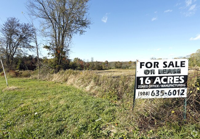
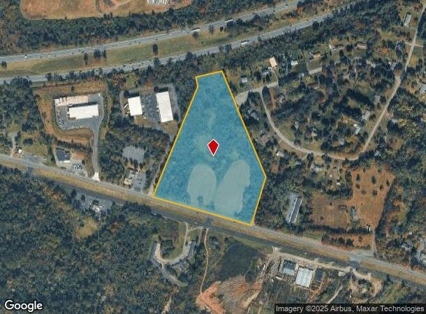
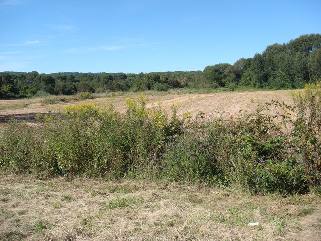
Property Record
1030 Route 22, Clinton, NJ 08809
NEARBY LISTINGS FOR SALE OR LEASE
Property Detail
1030 Route 22
06-00004-03-00028-0000-Q0295
Hunterdon
Farms
New Jersey
A
28
34019C0143F
16.32 AC
2024
Route 78 West
2025
Northern New Jersey
010801
Newark, NJ-PA
DEMOGRAPHICS near 1030 Route 22
1 Mile
3 Mile
5 Mile
2024 Total Population
1,099
9,313
26,433
2029 Population
1,103
9,463
26,762
Pop Growth 2024-2029
+ 0.36%
+ 1.61%
+ 1.24%
Average Age
44
46
45
2024 Total Households
385
3,815
10,174
HH Growth 2024-2029
+ 0.52%
+ 1.49%
+ 1.36%
Median Household Inc
$150,379
$128,681
$128,276
Avg Household Size
2.80
2.40
2.50
2024 Avg HH Vehicles
3.00
2.00
2.00
Median Home Value
$478,632
$483,090
$487,346
Median Year Built
1967
1983
1980
Nearby Places
Map Layers
Map Styles
 Street
 Aerial
- Restaurants
- Banks
- Shops
- Fitness
- Groceries
PUBLIC TRANSPORTATION
COMMUTER RAIL
Lebanon (Raritan Valley Line - NJ Transit Commuter Rail (NJ Transit))
DRIVE
WALK
Distance
Lebanon (Raritan Valley Line - NJ Transit Commuter Rail (NJ Transit))
5 min
2.0 mi
White House (Raritan Valley Line - NJ Transit Commuter Rail (NJ Transit))
DRIVE
WALK
Distance
White House (Raritan Valley Line - NJ Transit Commuter Rail (NJ Transit))
7 min
3.9 mi
AIRPORT
Trenton Mercer
DRIVE
WALK
Distance
Trenton Mercer
55 min
35.5 mi
Freight Ports
New York Container Terminal
DRIVE
WALK
Distance
New York Container Terminal
57 min
43.8 mi
SALE & LEASE HISTORY
LISTING DATE
SALE/LEASE

Nov 17, 2017
For Sale
Nearby Properties
Address
Land Use
TOTAL SIZE
Lot Size
Zoning
Address
Land Use
TOTAL SIZE
Lot Size
Zoning
3,703.19 AC
RC
Address
Land Use
TOTAL SIZE
Lot Size
Zoning
187,596 SF
54.59 AC
RO
Address
Land Use
TOTAL SIZE
Lot Size
Zoning
61.69 AC
RO
Address
Land Use
TOTAL SIZE
Lot Size
Zoning
8,000 SF
17.12 AC
RO
Address
Land Use
TOTAL SIZE
Lot Size
Zoning
29,982 SF
7.76 AC
Address
Land Use
TOTAL SIZE
Lot Size
Zoning
76.99 AC
ROM2
Address
Land Use
TOTAL SIZE
Lot Size
Zoning
14,182 SF
77.17 AC
ROMX
Address
Land Use
TOTAL SIZE
Lot Size
Zoning
20 AC
AR
Address
Land Use
TOTAL SIZE
Lot Size
Zoning
10,863 SF
77 AC
ROM1
Address
Land Use
TOTAL SIZE
Lot Size
Zoning
58,471 SF
8.69 AC
B
Address
Land Use
TOTAL SIZE
Lot Size
Zoning
20,764 SF
21.01 AC
ROM1
Address
Land Use
TOTAL SIZE
Lot Size
Zoning
4.61 AC
Address
Land Use
TOTAL SIZE
Lot Size
Zoning
6.52 AC
B
Address
Land Use
TOTAL SIZE
Lot Size
Zoning
1,620 SF
15.85 AC
C2
Address
Land Use
TOTAL SIZE
Lot Size
Zoning
10.99 AC
ROM1
Address
Land Use
TOTAL SIZE
Lot Size
Zoning
25 AC
RC
Address
Land Use
TOTAL SIZE
Lot Size
Zoning
1,056 SF
4 AC
Address
Land Use
TOTAL SIZE
Lot Size
Zoning
4.70 AC
Address
Land Use
TOTAL SIZE
Lot Size
Zoning
Address
Land Use
TOTAL SIZE
Lot Size
Zoning
8.50 AC
Address
Land Use
TOTAL SIZE
Lot Size
Zoning
37,951 SF
21.49 AC
AR
Address
Land Use
TOTAL SIZE
Lot Size
Zoning
9,200 SF
10.95 AC
Address
Land Use
TOTAL SIZE
Lot Size
Zoning
62,140 SF
6 AC
B
Address
Land Use
TOTAL SIZE
Lot Size
Zoning
7,782 SF
10 AC
ROM2
Address
Land Use
TOTAL SIZE
Lot Size
Zoning
Address
Land Use
TOTAL SIZE
Lot Size
Zoning
26 AC
RO
Address
Land Use
TOTAL SIZE
Lot Size
Zoning
2.19 AC
Address
Land Use
TOTAL SIZE
Lot Size
Zoning
53,392 SF
7.47 AC
PND1
Address
Land Use
TOTAL SIZE
Lot Size
Zoning
21.27 AC
Address
Land Use
TOTAL SIZE
Lot Size
Zoning
0.83 AC
The World's #1 Commercial Real Estate Marketplace
Connect with us
© 2025 CoStar Group
The information above has been obtained from sources believed reliable. While we do not doubt its accuracy we have not verified it and make no guarantee, warranty or representation about it. It is your responsibility to independently confirm its accuracy and completeness. Any projections, opinions, assumptions, or estimates used are for example only and do not represent the current or future performance of the property. The value of this transaction to you depends on tax and other factors which should be evaluated by your tax, financial, and legal advisors. You and your advisors should conduct a careful, independent investigation of the property to determine to your satisfaction the suitability of the property for your needs.